Note
Access to this page requires authorization. You can try signing in or changing directories.
Access to this page requires authorization. You can try changing directories.
Switch services using the Version drop-down list. Learn more about navigation.
Applies to: ✅ Azure Data Explorer ✅ Azure Monitor ✅ Microsoft Sentinel
Calculates the shortest distance in meters between a coordinate and a line or multiline on Earth.
Syntax
geo_distance_point_to_line(longitude,latitude,lineString)
Learn more about syntax conventions.
Parameters
| Name | Type | Required | Description |
|---|---|---|---|
| longitude | real |
✔️ | The geospatial coordinate longitude value in degrees. A valid value is in the range [-180, +180]. |
| latitude | real |
✔️ | The geospatial coordinate latitude value in degrees. A valid value is in the range [-90, +90]. |
| lineString | dynamic |
✔️ | A line or multiline in the GeoJSON format. |
Returns
The shortest distance, in meters, between a coordinate and a line or multiline on Earth. If the coordinate or lineString are invalid, the query produces a null result.
Note
- The geospatial coordinates are interpreted as represented by the WGS-84 coordinate reference system.
- The geodetic datum used to measure distance on Earth is a sphere. Line edges are geodesics on the sphere.
- If input line edges are straight cartesian lines, consider using geo_line_densify() in order to convert planar edges to geodesics.
LineString definition and constraints
dynamic({"type": "LineString","coordinates": [[lng_1,lat_1], [lng_2,lat_2],..., [lng_N,lat_N]]})
dynamic({"type": "MultiLineString","coordinates": [[line_1, line_2, ..., line_N]]})
- LineString coordinates array must contain at least two entries.
- Coordinates [longitude, latitude] must be valid where longitude is a real number in the range [-180, +180] and latitude is a real number in the range [-90, +90].
- Edge length must be less than 180 degrees. The shortest edge between the two vertices is chosen.
Tip
- Using literal LineString or a MultiLineString may result in better performance.
- If you want to know the shortest distance between one or more points to many lines, consider folding these lines into one multiline. See the following example.
Examples
The following example finds the shortest distance between North Las Vegas Airport and a nearby road.
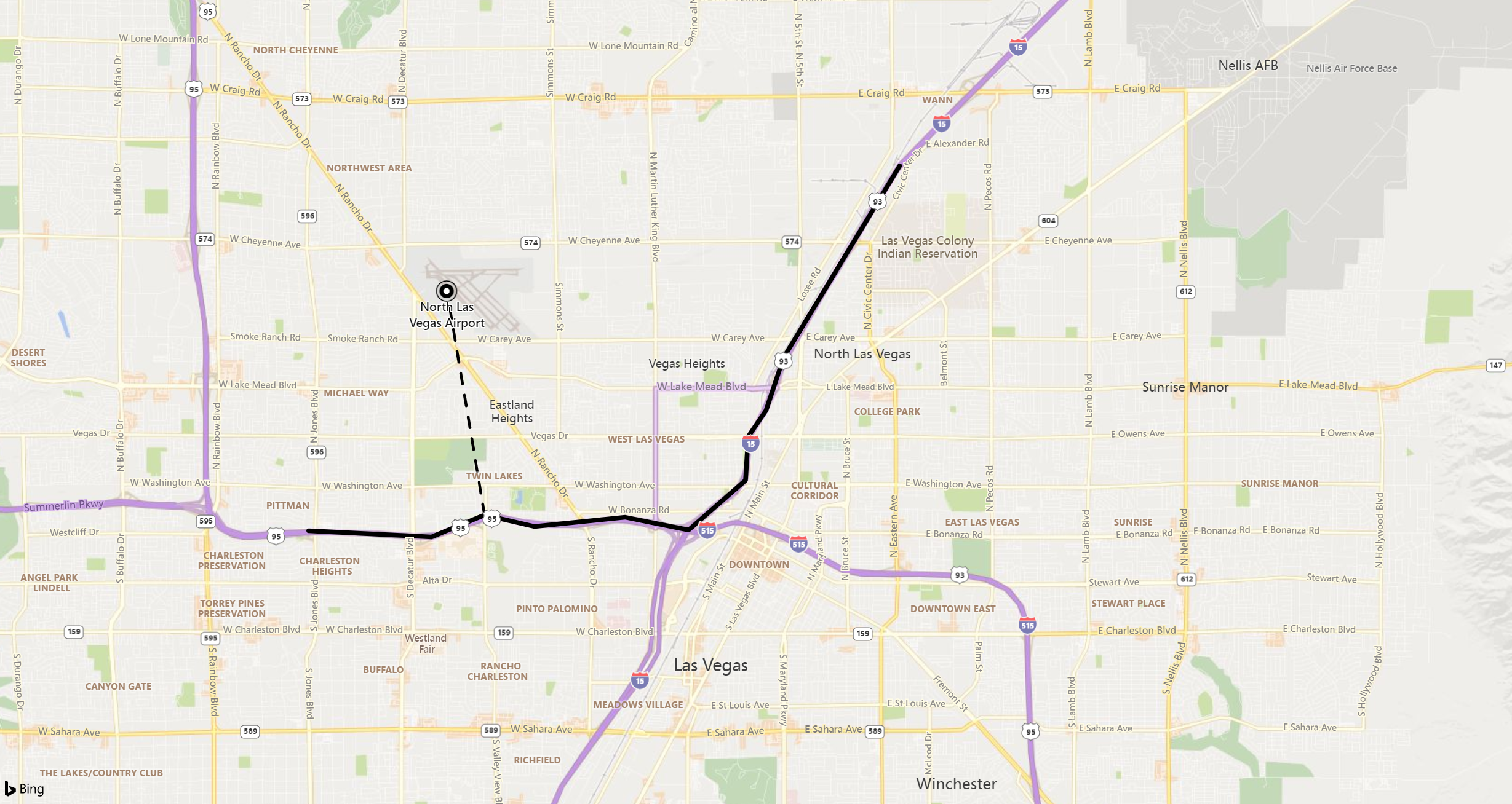
print distance_in_meters = geo_distance_point_to_line(-115.199625, 36.210419, dynamic({ "type":"LineString","coordinates":[[-115.115385,36.229195],[-115.136995,36.200366],[-115.140252,36.192470],[-115.143558,36.188523],[-115.144076,36.181954],[-115.154662,36.174483],[-115.166431,36.176388],[-115.183289,36.175007],[-115.192612,36.176736],[-115.202485,36.173439],[-115.225355,36.174365]]}))
Output
| distance_in_meters |
|---|
| 3797.88887253334 |
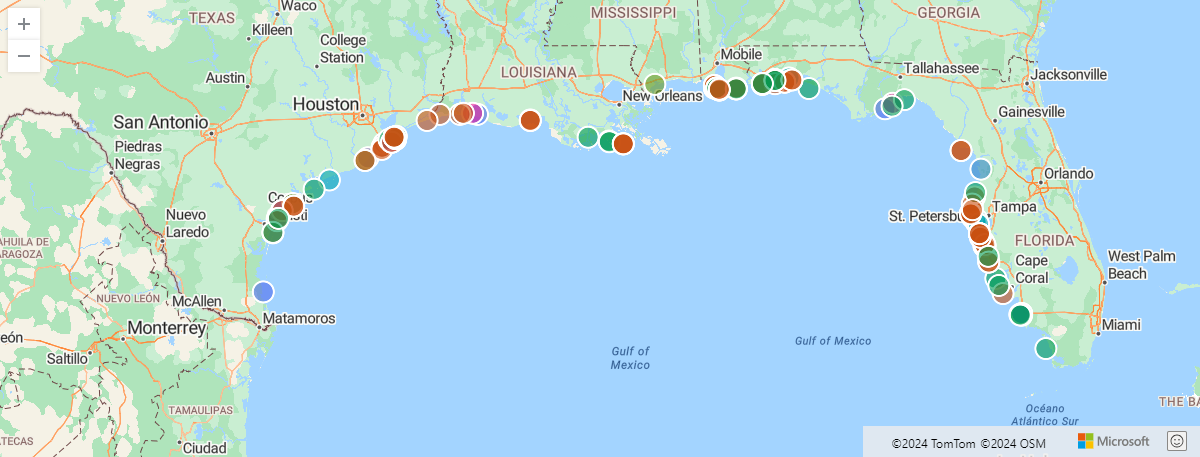
The following example finds storm events along the US south coast filtered by a maximum distance of 5 km from the defined shore line.
let southCoast = dynamic({"type":"LineString","coordinates":[[-97.18505859374999,25.997549919572112],[-97.58056640625,26.96124577052697],[-97.119140625,27.955591004642553],[-94.04296874999999,29.726222319395504],[-92.98828125,29.82158272057499],[-89.18701171875,29.11377539511439],[-89.384765625,30.315987718557867],[-87.5830078125,30.221101852485987],[-86.484375,30.4297295750316],[-85.1220703125,29.6880527498568],[-84.00146484374999,30.14512718337613],[-82.6611328125,28.806173508854776],[-82.81494140625,28.033197847676377],[-82.177734375,26.52956523826758],[-80.9912109375,25.20494115356912]]});
StormEvents
| project BeginLon, BeginLat, EventType
| where geo_distance_point_to_line(BeginLon, BeginLat, southCoast) < 5000
| render scatterchart with (kind=map)
Output
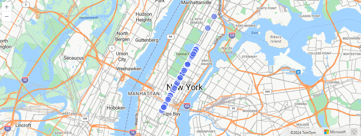
The following example finds New York taxi pickups filtered by a maximum distance of 0.1 meters from the defined multiline.
let MadisonAve = dynamic({"type":"MultiLineString","coordinates":[[[-73.9879823,40.7408625],[-73.9876492,40.7413345],[-73.9874982,40.7415046],[-73.9870343,40.7421446],[-73.9865812,40.7427655],[-73.9861292,40.7433756],[-73.9856813,40.7439956],[-73.9854932,40.7442606],[-73.9852232,40.7446216],[-73.9847903,40.7452305],[-73.9846232,40.7454536],[-73.9844803,40.7456606],[-73.9843413,40.7458585],[-73.9839533,40.7463955],[-73.9839002,40.7464696],[-73.9837683,40.7466566],[-73.9834342,40.7471015],[-73.9833833,40.7471746],[-73.9829712,40.7477686],[-73.9824752,40.7484255],[-73.9820262,40.7490436],[-73.9815623,40.7496566],[-73.9811212,40.7502796],[-73.9809762,40.7504976],[-73.9806982,40.7509255],[-73.9802752,40.7515216],[-73.9798033,40.7521795],[-73.9795863,40.7524656],[-73.9793082,40.7528316],[-73.9787872,40.7534725],[-73.9783433,40.7540976],[-73.9778912,40.7547256],[-73.9774213,40.7553365],[-73.9769402,40.7559816],[-73.9764622,40.7565766],[-73.9760073,40.7572036],[-73.9755592,40.7578366],[-73.9751013,40.7584665],[-73.9746532,40.7590866],[-73.9741902,40.7597326],[-73.9737632,40.7603566],[-73.9733032,40.7609866],[-73.9728472,40.7616205],[-73.9723422,40.7622826],[-73.9718672,40.7629556],[-73.9714042,40.7635726],[-73.9709362,40.7642185],[-73.9705282,40.7647636],[-73.9704903,40.7648196],[-73.9703342,40.7650355],[-73.9701562,40.7652826],[-73.9700322,40.7654535],[-73.9695742,40.7660886],[-73.9691232,40.7667166],[-73.9686672,40.7673375],[-73.9682142,40.7679605],[-73.9677482,40.7685786],[-73.9672883,40.7692076],[-73.9668412,40.7698296],[-73.9663882,40.7704605],[-73.9659222,40.7710936],[-73.9654262,40.7717756],[-73.9649292,40.7724595],[-73.9644662,40.7730955],[-73.9640012,40.7737285],[-73.9635382,40.7743615],[-73.9630692,40.7749936],[-73.9626122,40.7756275],[-73.9621172,40.7763106],[-73.9616111,40.7769896],[-73.9611552,40.7776245],[-73.9606891,40.7782625],[-73.9602212,40.7788866],[-73.9597532,40.7795236],[-73.9595842,40.7797445],[-73.9592942,40.7801635],[-73.9591122,40.7804105],[-73.9587982,40.7808305],[-73.9582992,40.7815116],[-73.9578452,40.7821455],[-73.9573802,40.7827706],[-73.9569262,40.7833965],[-73.9564802,40.7840315],[-73.9560102,40.7846486],[-73.9555601,40.7852755],[-73.9551221,40.7859005],[-73.9546752,40.7865426],[-73.9542571,40.7871505],[-73.9541771,40.7872335],[-73.9540892,40.7873366],[-73.9536971,40.7879115],[-73.9532792,40.7884706],[-73.9532142,40.7885205],[-73.9531522,40.7885826],[-73.9527382,40.7891785],[-73.9523081,40.7897545],[-73.9518332,40.7904115],[-73.9513721,40.7910435],[-73.9509082,40.7916695],[-73.9504602,40.7922995],[-73.9499882,40.7929195],[-73.9495051,40.7936045],[-73.9490071,40.7942835],[-73.9485542,40.7949065],[-73.9480832,40.7955345],[-73.9476372,40.7961425],[-73.9471772,40.7967915],[-73.9466841,40.7974475],[-73.9453432,40.7992905],[-73.9448332,40.7999835],[-73.9443442,40.8006565],[-73.9438862,40.8012945],[-73.9434262,40.8019196],[-73.9431412,40.8023325],[-73.9429842,40.8025585],[-73.9425691,40.8031855],[-73.9424401,40.8033609],[-73.9422987,40.8035533],[-73.9422013,40.8036857],[-73.9421022,40.8038205],[-73.9420024,40.8039552],[-73.9416372,40.8044485],[-73.9411562,40.8050725],[-73.9406471,40.8057176],[-73.9401481,40.8064135],[-73.9397022,40.8070255],[-73.9394081,40.8074155],[-73.9392351,40.8076495],[-73.9387842,40.8082715],[-73.9384681,40.8087086],[-73.9383211,40.8089025],[-73.9378792,40.8095215],[-73.9374011,40.8101795],[-73.936405,40.8115707],[-73.9362328,40.8118098]],[[-73.9362328,40.8118098],[-73.9362432,40.8118567],[-73.9361239,40.8120222],[-73.9360302,40.8120805]],[[-73.9362328,40.8118098],[-73.9361571,40.8118294],[-73.9360443,40.8119993],[-73.9360302,40.8120805]],[[-73.9360302,40.8120805],[-73.9359423,40.8121378],[-73.9358551,40.8122385],[-73.9352181,40.8130815],[-73.9348702,40.8135515],[-73.9347541,40.8137145],[-73.9346332,40.8138615],[-73.9345542,40.8139595],[-73.9344981,40.8139945],[-73.9344571,40.8140165],[-73.9343962,40.8140445],[-73.9343642,40.8140585],[-73.9343081,40.8140725],[-73.9341971,40.8140895],[-73.9341041,40.8141005],[-73.9340022,40.8140965],[-73.9338442,40.8141005],[-73.9333712,40.8140895],[-73.9325541,40.8140755],[-73.9324561,40.8140705],[-73.9324022,40.8140695]],[[-73.9360302,40.8120805],[-73.93605,40.8121667],[-73.9359632,40.8122805],[-73.9353631,40.8130795],[-73.9351482,40.8133625],[-73.9350072,40.8135415],[-73.9347441,40.8139168],[-73.9346611,40.8140125],[-73.9346101,40.8140515],[-73.9345401,40.8140965],[-73.9344381,40.8141385],[-73.9343451,40.8141555],[-73.9342991,40.8141675],[-73.9341552,40.8141985],[-73.9338601,40.8141885],[-73.9333991,40.8141815],[-73.9323981,40.8141665]]]});
nyc_taxi
| project pickup_longitude, pickup_latitude
| where geo_distance_point_to_line(pickup_longitude, pickup_latitude, MadisonAve) <= 0.1
| take 100
| render scatterchart with (kind=map)
Output
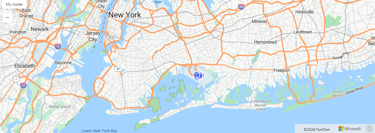
The following example folds many lines into one multiline and queries this multiline. The query finds all taxi pickups that happened 10 km away from all roads in Manhattan.
let ManhattanRoads =
    datatable(features:dynamic)
    [
        dynamic({"type":"Feature","properties":{"Label":"145thStreetBrg"},"geometry":{"type":"MultiLineString","coordinates":[[[-73.9322259,40.8194635],[-73.9323259,40.8194743],[-73.9323973,40.8194779]]]}}),
        dynamic({"type":"Feature","properties":{"Label":"W120thSt"},"geometry":{"type":"MultiLineString","coordinates":[[[-73.9619541,40.8104844],[-73.9621542,40.8105725],[-73.9630542,40.8109455],[-73.9635902,40.8111714],[-73.9639492,40.8113174],[-73.9640502,40.8113705]]]}}),
        dynamic({"type":"Feature","properties":{"Label":"1stAve"},"geometry":{"type":"MultiLineString","coordinates":[[[-73.9704124,40.748033],[-73.9702043,40.7480906],[-73.9696892,40.7487346],[-73.9695012,40.7491976],[-73.9694522,40.7493196]],[[-73.9699932,40.7488636],[-73.9694522,40.7493196]],[[-73.9694522,40.7493196],[-73.9693113,40.7494946],[-73.9688832,40.7501056],[-73.9686562,40.7504196],[-73.9684231,40.7507476],[-73.9679832,40.7513586],[-73.9678702,40.7514986]],[[-73.9676833,40.7520426],[-73.9675462,40.7522286],[-73.9673532,40.7524976],[-73.9672892,40.7525906],[-73.9672122,40.7526806]]]}})
        // ... more roads ...
    ];
let allRoads=toscalar(
    ManhattanRoads
    | project road_coordinates=features.geometry.coordinates
    | summarize make_list(road_coordinates)
    | project multiline = bag_pack("type","MultiLineString", "coordinates", list_road_coordinates));
nyc_taxi
| project pickup_longitude, pickup_latitude
| where pickup_longitude != 0 and pickup_latitude != 0
| where geo_distance_point_to_line(pickup_longitude, pickup_latitude, parse_json(allRoads)) > 10000
| take 10
| render scatterchart with (kind=map)
Output
The following example returns a null result because of the invalid LineString input.
print distance_in_meters = geo_distance_point_to_line(1,1, dynamic({ "type":"LineString"}))
Output
| distance_in_meters |
|---|
The following example returns a null result because of the invalid coordinate input.
print distance_in_meters = geo_distance_point_to_line(300, 3, dynamic({ "type":"LineString","coordinates":[[1,1],[2,2]]}))
Output
| distance_in_meters |
|---|