Note
Access to this page requires authorization. You can try signing in or changing directories.
Access to this page requires authorization. You can try changing directories.
Switch services using the Version drop-down list. Learn more about navigation.
Applies to: ✅ Azure Data Explorer ✅ Azure Monitor ✅ Microsoft Sentinel
Calculates the centroid of a polygon or a multipolygon on Earth.
Syntax
geo_polygon_centroid(polygon)
Learn more about syntax conventions.
Parameters
| Name | Type | Required | Description |
|---|---|---|---|
| polygon | dynamic |
✔️ | Polygon or multipolygon in the GeoJSON format. |
Returns
The centroid coordinate values in GeoJSON Format and of a dynamic data type. If polygon or multipolygon are invalid, the query produces a null result.
Note
- The geospatial coordinates are interpreted as represented by the WGS-84 coordinate reference system.
- The geodetic datum used for measurements on Earth is a sphere. Polygon edges are geodesics on the sphere.
- If input polygon edges are straight cartesian lines, consider using geo_polygon_densify() to convert planar edges to geodesics.
- If input is a multipolygon and contains more than one polygon, the result will be the centroid of polygons union.
Polygon definition and constraints
dynamic({"type": "Polygon","coordinates": [ LinearRingShell, LinearRingHole_1, ..., LinearRingHole_N ]})
dynamic({"type": "MultiPolygon","coordinates": [[ LinearRingShell, LinearRingHole_1, ..., LinearRingHole_N], ..., [LinearRingShell, LinearRingHole_1, ..., LinearRingHole_M]]})
- LinearRingShell is required and defined as a
counterclockwiseordered array of coordinates [[lng_1,lat_1],...,[lng_i,lat_i],...,[lng_j,lat_j],...,[lng_1,lat_1]]. There can be only one shell. - LinearRingHole is optional and defined as a
clockwiseordered array of coordinates [[lng_1,lat_1],...,[lng_i,lat_i],...,[lng_j,lat_j],...,[lng_1,lat_1]]. There can be any number of interior rings and holes. - LinearRing vertices must be distinct with at least three coordinates. The first coordinate must be equal to the last. At least four entries are required.
- Coordinates [longitude, latitude] must be valid. Longitude must be a real number in the range [-180, +180] and latitude must be a real number in the range [-90, +90].
- LinearRingShell encloses at most half of the sphere. LinearRing divides the sphere into two regions and chooses the smaller of the two regions.
- LinearRing edge length must be less than 180 degrees. The shortest edge between the two vertices is chosen.
- LinearRings must not cross and must not share edges. LinearRings might share vertices.
Examples
The following example calculates the Central Park centroid in New York City.
let central_park = dynamic({"type":"Polygon","coordinates":[[[-73.9495,40.7969],[-73.95807266235352,40.80068603561921],[-73.98201942443848,40.76825672305777],[-73.97317886352539,40.76455136505513],[-73.9495,40.7969]]]});
print centroid = geo_polygon_centroid(central_park)
Output
| centroid |
|---|
| {"type": "Point", "coordinates": [-73.965735689907618, 40.782550538057812]} |
The following example calculates the Central Park centroid longitude.
let central_park = dynamic({"type":"Polygon","coordinates":[[[-73.9495,40.7969],[-73.95807266235352,40.80068603561921],[-73.98201942443848,40.76825672305777],[-73.97317886352539,40.76455136505513],[-73.9495,40.7969]]]});
print
centroid = geo_polygon_centroid(central_park)
| project lng = centroid.coordinates[0]
Output
| lng |
|---|
| -73.9657356899076 |
The following example performs union of polygons in multipolygon and calculates the centroid of the unified polygon.
let polygons = dynamic({"type":"MultiPolygon","coordinates":[[[[-73.9495,40.7969],[-73.95807266235352,40.80068603561921],[-73.98201942443848,40.76825672305777],[-73.97317886352539,40.76455136505513],[-73.9495,40.7969]]],[[[-73.94262313842773,40.775991804565585],[-73.98107528686523,40.791849155467695],[-73.99600982666016,40.77092185281977],[-73.96150588989258,40.75609977566361],[-73.94262313842773,40.775991804565585]]]]});
print polygons_union_centroid = geo_polygon_centroid(polygons)
Output
| polygons_union_centroid |
|---|
| "type": "Point", "coordinates": [-73.968569587829577, 40.776310752555119]} |
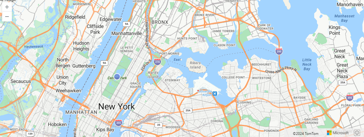
The following example visualizes the Central Park centroid on a map.
let central_park = dynamic({"type":"Polygon","coordinates":[[[-73.9495,40.7969],[-73.95807266235352,40.80068603561921],[-73.98201942443848,40.76825672305777],[-73.97317886352539,40.76455136505513],[-73.9495,40.7969]]]});
print
centroid = geo_polygon_centroid(central_park)
| render scatterchart with (kind = map)
Output
The following example returns true because of the invalid polygon.
print isnull(geo_polygon_centroid(dynamic({"type": "Polygon","coordinates": [[[0,0],[10,10],[10,10],[0,0]]]})))
Output
| print_0 |
|---|
| true |