geo_point_to_geohash()
计算地理位置的 geohash 字符串值。
详细了解 geohash。
语法
geo_point_to_geohash(longitude,latitude,[ accuracy ])
详细了解语法约定。
参数
| 客户 | 类型 | 必需 | 说明 |
|---|---|---|---|
| longitude | real |
✔ | 地理空间坐标经度值(度)。 有效值为 [-180, +180] 范围内的实数。 |
| latitude | real |
✔ | 地理空间坐标纬度值(度)。 有效值为 [-90, +90] 范围内的实数。 |
| accuracy | int |
定义所请求的准确度。 支持的值范围为 [1, 18]。 如果未指定,则使用默认值 5。 |
返回
其长度具有所请求的准确度的给定地理位置的 geohash 字符串值。 如果坐标或准确度无效,则查询会生成空结果。
注意
- Geohash 是一个有用的地理空间聚类分析工具。
- Geohash 有 18 个准确度级别,区域覆盖范围从最高级别 (1) 的 2500 万 km² 到最低级别 (18) 的 0.6 μ²。
- geohash 的共有前缀表示点之间的靠近程度。 共享前缀越长,两个位置越靠近。 准确度值将转换为 geohash 长度。
- Geohash 是平面表面上的一个矩形区域。
- 对通过经度 x 和纬度 y 计算的 geohash 字符串调用 geo_geohash_to_central_point() 函数不一定返回 x 和 y。
- 根据 geohash 定义,有可能两个地理位置非常靠近,但有不同的 geohash 代码。
每个准确度值对应的 Geohash 矩形区域覆盖范围:
| 精确度 | 宽度 | 高度 |
|---|---|---|
| 1 | 5000 km | 5000 km |
| 2 | 1250 km | 625 km |
| 3 | 156.25 km | 156.25 km |
| 4 | 39.06 km | 19.53 km |
| 5 | 4.88 km | 4.88 km |
| 6 | 1.22 km | 0.61 km |
| 7 | 152.59 m | 152.59 m |
| 8 | 38.15 m | 19.07 m |
| 9 | 4.77 m | 4.77 m |
| 10 | 1.19 m | 0.59 m |
| 11 | 149.01 mm | 149.01 mm |
| 12 | 37.25 mm | 18.63 mm |
| 13 | 4.66 mm | 4.66 mm |
| 14 | 1.16 mm | 0.58 mm |
| 15 | 145.52 μ | 145.52 μ |
| 16 | 36.28 μ | 18.19 μ |
| 17 | 4.55 μ | 4.55 μ |
| 18 | 1.14 μ | 0.57 μ |
另请参阅 geo_point_to_s2cell() 和 geo_point_to_h3cell()。
有关与其他可用网格系统的比较,请参阅使用 Kusto 查询语言进行地理空间聚类分析。
示例
按 geohash 聚合的美国风暴事件。
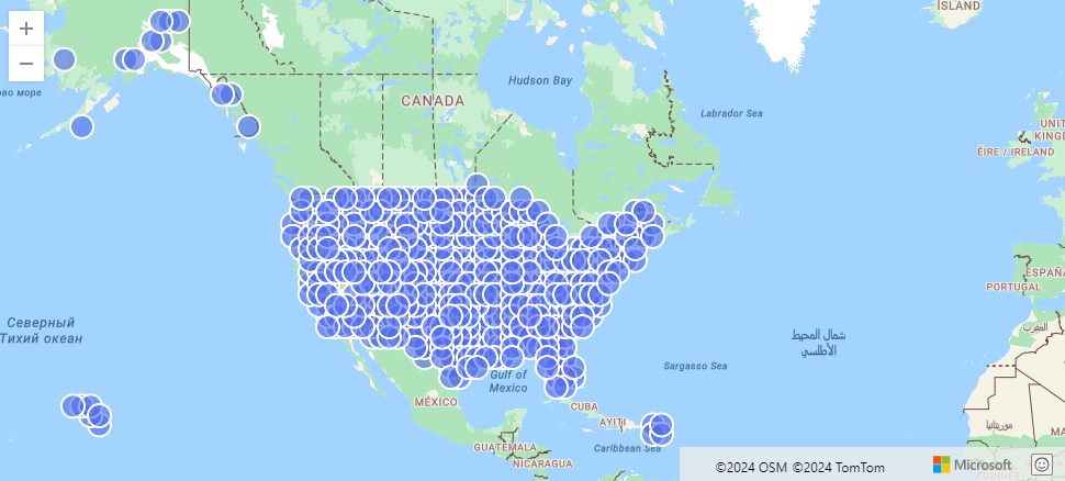
StormEvents
| project BeginLon, BeginLat
| summarize by hash=geo_point_to_geohash(BeginLon, BeginLat, 3)
| project geo_geohash_to_central_point(hash)
| render scatterchart with (kind=map)
print geohash = geo_point_to_geohash(139.806115, 35.554128, 12)
输出
| geohash |
|---|
| xn76m27ty9g4 |
print geohash = geo_point_to_geohash(-80.195829, 25.802215, 8)
输出
| geohash |
|---|
| dhwfz15h |
以下示例查找坐标组。 组中的每对坐标都位于一个 4.88 km X 4.88 km 的矩形区域内。
datatable(location_id:string, longitude:real, latitude:real)
[
  "A", double(-122.303404), 47.570482,
  "B", double(-122.304745), 47.567052,
  "C", double(-122.278156), 47.566936,
]
| summarize count = count(),                                          // items per group count
            locations = make_list(location_id)                        // items in the group
            by geohash = geo_point_to_geohash(longitude, latitude)    // geohash of the group
输出
| geohash | 计数 | locations |
|---|---|---|
| c23n8 | 2 | ["A", "B"] |
| c23n9 | 1 | ["C"] |
由于坐标输入无效,以下示例生成空结果。
print geohash = geo_point_to_geohash(200,1,8)
输出
| geohash |
|---|
由于准确度输入无效,以下示例生成空结果。
print geohash = geo_point_to_geohash(1,1,int(null))
输出
| geohash |
|---|